Worcester

Find Businesses and Services in Worcester, Western Cape
Please select your preferred Industry:
- Worcester Accommodation
- Worcester Arts & Entertainment
- Worcester Attractions
- Worcester Business Services & Finance
- Worcester Golf
- Worcester Health & Beauty
- Worcester Restaurants; Food & Drink
- Worcester Science & Nature
- Worcester Shopping & Auctions
- Worcester Sports & Leisure
- Worcester Travel & Tourism
Add a Business to Worcester
Map of Worcester
Featured Businesses
KWV2008-11-13
Located in Worcester, Breede Valley, Western Cape, South Africa
 The KWV, Worcester, South Africa, stabilise the SA Wine Industry, during which it fulfilled the role of custodian and regulator of the South African Wine Industry, to the dawn of the 21st Century, KWV has pioneered the way forward for the industry. READ MORE
Damas Events2008-11-14
Located in Worcester, Breede Valley, Western Cape, South Africa
 Damas Events, Worcester, South Africa, provide the ideal environment for conferences, is a popular wedding venue, and is a very popular venue for most of the country?s leading musicians and performers.READ MORE
Featured Businesses
Kleinplasie 2008-11-14
Located in Worcester, Breede Valley, Western Cape, South Africa
 Kleinplasie, Worcester, South Africa, is a living Open-air Museum depicting the lifestyle of the early Cape pioneer farmers. Activities like tobacco rolling, candle and soap making, coffee roasting and bread baking are performed on a daily basis.READ MORE
Mountain Mill Shopping Centre2008-11-13
Located in Worcester, Breede Valley, Western Cape, South Africa
 At Mountain Mill Shopping Centre, Worcester, South Africa, we strive to make your shopping experience one to remember. We offer from grocery stores to fashion retailers, from lifestyle stores to restaurants and food outlets. READ MORE
National Institute for the Deaf2008-11-18
Located in Worcester, Breede Valley, Western Cape, South Africa
 The National Institute for the Deaf, Worcester, South Africa, aims to develop the full potential of every Deaf person through basic education, training, welfare services and spiritual care.
READ MORE
The National Institute for the Deaf, Worcester, South Africa, aims to develop the full potential of every Deaf person through basic education, training, welfare services and spiritual care.
READ MOREInstitute for the Blind2008-11-18
Located in Worcester, Breede Valley, Western Cape, South Africa
 Institute for the Blind, Worcester, South Africa, create a future for visually impaired persons and to empower persons who are: Blind - Partially sighted - Deaf blind, including - Persons with additional disabilities.
By means of: Education - Training - Development and Care ...towards a fulfilled life and complete citizenship.READ MORE
Institute for the Blind, Worcester, South Africa, create a future for visually impaired persons and to empower persons who are: Blind - Partially sighted - Deaf blind, including - Persons with additional disabilities.
By means of: Education - Training - Development and Care ...towards a fulfilled life and complete citizenship.READ MOREOverhex Wines International2008-11-18
Located in Worcester, Breede Valley, Western Cape, South Africa
 Overhex Wines International, Worcester, South Africa, make wines to accompany all of life?s precious moments. From crisp, well-balanced whites to deliciously fruity rosés and spicy reds, our wine ranges are perfectly blended and lovingly matured to help you enjoy every moment of your life.READ MORE
Worcester Golf Course2008-11-18
Located in Worcester, Breede Valley, Western Cape, South Africa
 Worcester Golf Course, Worcester, South Africa, is a challenging course, which rewards daring shots but can severely punish bad ones. The large bent grass greens were built and are maintained to the highest standards.READ MORE
Virtual Office Assistance - Typing and Transcription2010-05-30
Located in Worcester, Breede Valley, Western Cape, South Africa
 This company whose owner has more than 20 years experience in administrative services to a variety of business fields, offers quality services, tailored to the needs of the busy entrepreneur, business manager or individual.READ MORE
The Habit 2008-11-13
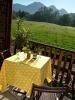
Located in Worcester, Breede Valley, Western Cape, South Africa
 The Habit, Worcester, South Africa, is a four star graded guest house and AA Superior graded which guarantees certain minimum standards. It offers 6 luxury en-suite rooms, a comfortable guest lounge with bar and fireplace. The original Oregon Pine flooring creates warmth and comfort all year round.READ MORE
Damas Restaurant 2008-11-14
Located in Worcester, Breede Valley, Western Cape, South Africa
 Damas Restaurant, Worcester, South Africa, ia an award-winning restaurant, offers excellent cuisine, warm hospitality, first-class service and awarded wines from the Breede River Valley.READ MORE
The Prime Spot Guest House2008-11-15
Located in Worcester, Breede Valley, Western Cape, South Africa
 The Prime Spot Guest House, Worcester, South Africa, is situated in the historic Church street in the center of the town and has a lovely tranquil garden where flowers and birds abound.READ MORE
Deafblind South Africa2008-11-18
Located in Worcester, Breede Valley, Western Cape, South Africa
 Deafblind South Africa, Worcester, South Africa, sees its role as a lobbying organisation to promote better services for Deafblind people and also to be the mouthpiece of Deafblind people in South Africa. The main objective is to break the isolation that surrounds Deafblind people.READ MORE
Summer Hill Farm2008-11-18
Located in Worcester, Breede Valley, Western Cape, South Africa
 Summer Hill Farm, Worcester, South Africa, is ideally situated for exploration of the Breede River Valley and Route 62. A friendly welcome, a relaxed home from home stay on a grape farm, 6 fully equipped charmingly decorated units at your disposal.READ MORE
The Good Habit2008-11-13
Located in Worcester, Breede Valley, Western Cape, South Africa
 The Good Habit, Worcester, South Africa, are out to change habits all over the world, It has been scientifically proven that red wine is beneficial if drunk daily on a moderate scale. It is good in the prevention of build-up in the arteries and is known to decrease risk with the incidence of strokes. So drink up!! READ MORE
Reed's Country Lodge2008-11-13
Located in Worcester, Breede Valley, Western Cape, South Africa
 Reed's Country Lodge, Worcester, South Africa, has the facilities to make your stay worthwhile and enjoyable, whether you're old, or young. A nice breakaway for the whole family. For the more adventurous? Kayaking, paragliding, abseiling, Quad biking! READ MORE
The Cape Gliding Club 2008-11-13
Located in Worcester, Breede Valley, Western Cape, South Africa
 The Cape Gliding Club, Worcester, South Africa, is a non-profit organisation dedicated to the promotion and enjoyment of soaring in the Western Cape province of South Africa. "The Art of Soaring is the science of using energy from air currents to lift, and sustain the sailplane aloft."READ MORE
Damas Bed and Breakfast2008-11-14
Located in Worcester, Breede Valley, Western Cape, South Africa
 Damas Bed and Breakfast, Worcester, South Africa, nestles amongst the vineyards in the picturesque Brandwacht Valley, with warm hospitality and first-class service.READ MORE
Reed's Country Lodge Conference2008-11-14
Located in Worcester, Breede Valley, Western Cape, South Africa
 Reed's Country Lodge Conference, Worcester, South Africa, offers the perfect spot for a top management conference, an executive board meeting, team building, a budget conference or a strategy meeting. READ MORE
Church Street Lodge2008-11-13
Located in Worcester, Breede Valley, Western Cape, South Africa
 Church Street Lodge, Worcester, South Africa, offers private parking, a swimming pool, fountains, quaint patios, braai facilities and a beautifully tranquil garden, situated amidst magnificent mountain ranges and beautiful vineyards.READ MORE
Karoo Desert National Botanical Garden2008-11-14
Located in Worcester, Breede Valley, Western Cape, South Africa
 Karoo Desert National Botanical Garden, Worcester, South Africa, the only truly succulent garden in the southern hemisphere and on the African continent. A must for succulent lovers, the Garden lies on the outskirts of Worcester.READ MORE
>